


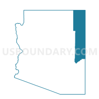
Sweetwater Voting District, Apache County, Arizona
About
Outline

Summary
| Unique Area Identifier | 523606 |
| Name | Sweetwater Voting District |
| County | Apache County |
| State | Arizona |
| Area (square miles) | 207.21 |
| Land Area (square miles) | 207.11 |
| Water Area (square miles) | 0.10 |
| % of Land Area | 99.95 |
| % of Water Area | 0.05 |
| Latitude of the Internal Point | 36.78976950 |
| Longtitude of the Internal Point | -109.35165210 |
Maps


Graphs
Select a template below for downloading or customizing gragh for Sweetwater Voting District, Apache County, Arizona


Neighbors
Neighoring Voting District (by Name) Neighboring Voting District on the Map
- Mexican Water Voting District, Apache County, AZ
- Red Mesa Voting District, Apache County, AZ
- Red Valley Voting District, Apache County, AZ
- Rock Point Voting District, Apache County, AZ
- Round Rock Voting District, Apache County, AZ
- Teec Nos Pos Voting District, Apache County, AZ